| Time |
Distance |
Instruction |
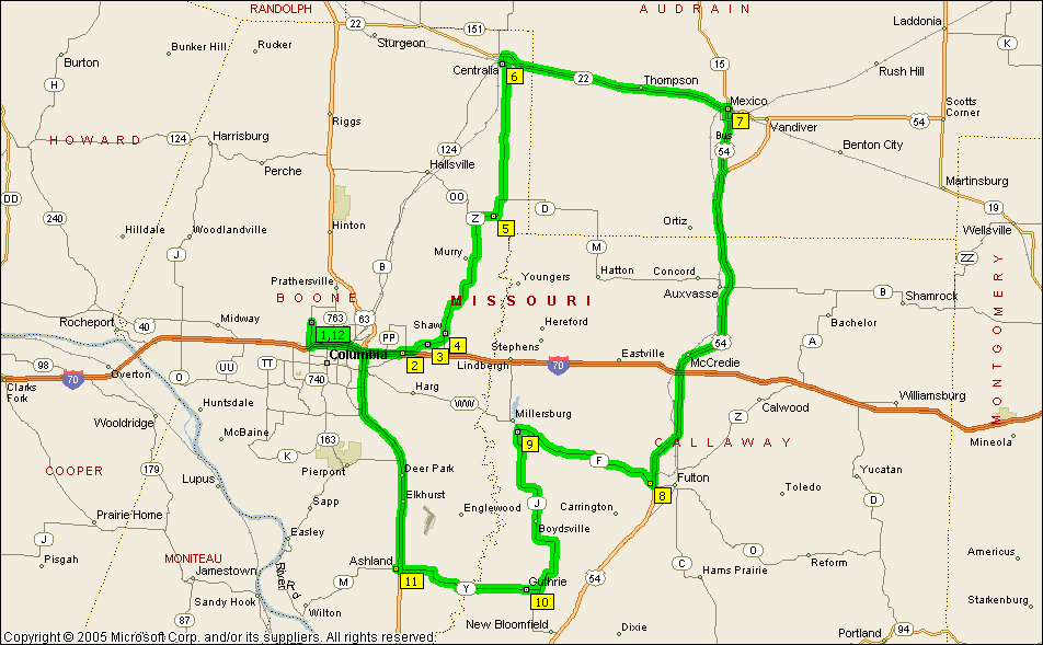
| 2:00 PM | 0.0 | 1 Depart W
Prairieview Dr, Columbia, MO 65202 on N Creasy Springs Rd (South) for 1.5 mi |
| 2:03 PM | 1.5 | At roundabout, take the THIRD exit onto I-70 Bus for 0.1 mi |
| 2:03 PM | 1.6 | Take Ramp (LEFT) onto I-70 [US-40] for 5.2 mi towards I-70 / US-40 |
| 2:08 PM | 6.8 | At exit 131, turn RIGHT onto Ramp for 0.2 mi towards Lake of the Woods Road |
| 2:08 PM | 7.0 | Turn LEFT (North) onto (E) St Charles Rd for 0.2 mi |
| 2:09 PM | 7.2 | Turn RIGHT (East) onto Local road(s) for 0.2 mi* |
| 2:10 PM | 7.3 | 2
to return an
anti-fogging shield that didn't fit my helmet, return North-West on Local road(s) for 0.2 mi. |
| 2:10 PM | 7.5 | Turn RIGHT (North) onto E St Charles Rd for 1.8 mi |
| 2:15 PM | 9.3 | 3 At E St Charles Rd,
stay on E St Charles Rd (East) for 1.1 mi |
| 2:18 PM | 10.4 | Bear LEFT (North) onto SR-Z for 0.4 mi. |
| 2:19 PM | 10.8 | 4 At Shaw, stay on
SR-Z (North) for 9.1 mi |
| 2:33 PM | 19.9 | 5 At SR-Z, stay on
SR-Z (East) for 8.5 mi |
| 2:47 PM | 28.4 | Keep STRAIGHT onto SR-Z [S Jefferson St] for 0.9 mi |
| 2:49 PM | 29.3 | Keep STRAIGHT onto SR-Z [N Jefferson St] for 43 yds |
| 2:49 PM | 29.3 | Turn LEFT (West) onto (E) Singleton St for 0.3 mi |
| 2:50 PM | 29.6 | Keep STRAIGHT onto SR-124 [W Singleton St] for 54 yds |
| 2:51 PM | 29.7 | 6 At Centralia,
return East on SR-124 [W Singleton St] for 54 yds |
| 2:51 PM | 29.7 | Turn LEFT (North) onto SR-124 [N Allen St] for 0.5 mi |
| 2:51 PM | 30.2 | Turn RIGHT (East) onto SR-22 [Hinman St] for 14.0 mi |
| 3:10 PM | 44.2 | Turn RIGHT (South) onto SR-15 [SR-22] for 54 yds. |
| 3:10 PM | 44.2 | 7 At Mexico, stay on
Getting from SR-22 to US-54 requires navigating through downtown Mexico. (An intersting note: It's only 27
miles from Mexico to Paris - at least if you are in Missouri.) |
| 3:11 PM | 45.1 | Turn RIGHT (South) onto US-54 Bus [SR-15] for 3.2 mi |
| 3:16 PM | 48.3 | Take Ramp (RIGHT) onto US-54 for 20.8 mi towards US-54. |
| 3:41 PM | 69.1 | Keep RIGHT onto Ramp for 0.2 mi towards MO-F / Fulton / Millersburg. |
| 3:41 PM | 69.3 | Turn RIGHT (West) onto SR-F [Martin Luther King Dr] for 0.2 mi |
| 3:41 PM | 69.5 | 8 At SR-F, stay on
SR-F [Martin Luther King Dr] (West) for 0.5 mi |
| 3:42 PM | 70.0 | Keep STRAIGHT onto SR-F for 8.6 mi |
| 3:56 PM | 78.6 | Turn LEFT (South) onto SR-J for 0.2 mi. SR-J |
| 3:57 PM | 78.7 | 9 At 4657 SR-J,
Fulton, MO 65251, stay on SR-J (South) for 11.9 mi |
| 4:16 PM | 90.6 | Turn RIGHT (West) onto SR-Y for 0.8 mi |
| 4:17 PM | 91.5 | 10 At Guthrie, stay
on SR-Y (West) for 8.3 mi |
| 4:31 PM | 99.7 | Road name changes to SR-M [SR-Y] for 164 yds |
| 4:31 PM | 99.8 | Keep STRAIGHT onto SR-M [E Broadway] for 0.2 mi |
| 4:32 PM | 100.0 | 11 At Ashland,
return East on SR-M [E Broadway] for 0.2 mi |
| 4:32 PM | 100.2 | Keep STRAIGHT onto SR-M [SR-Y] for 164 yds |
| 4:32 PM | 100.3 | Take Ramp (LEFT) onto US-63 for 13.3 mi towards US-63 |
| 4:48 PM | 113.6 | Keep RIGHT onto Ramp for 0.4 mi towards I-70 / US-40 / MO-PP / St Louis / Kansas City |
| 4:49 PM | 114.0 | Keep STRAIGHT onto N US-63 for 0.2 mi |
| 4:49 PM | 114.3 | Take Ramp (LEFT) onto I-70 [US-40] for 3.1 mi towards I-70 / US-40 |
| 4:52 PM | 117.4 | At exit 125, turn RIGHT onto Ramp for 0.2 mi towards West Blvd |
| 4:52 PM | 117.6 | Keep RIGHT to stay on Ramp for 32 yds |
| 4:52 PM | 117.6 | At roundabout, take the FIRST exit onto N Creasy Springs Rd for 1.5 mi |
| 4:56 PM | 119.1 | 12 Arrive W
Prairieview Dr, Columbia, MO 65202 |
| *The 2005 version of Microsoft Streets and Trips is missing some of the roads on which I road on
this trip. |